| diagram | 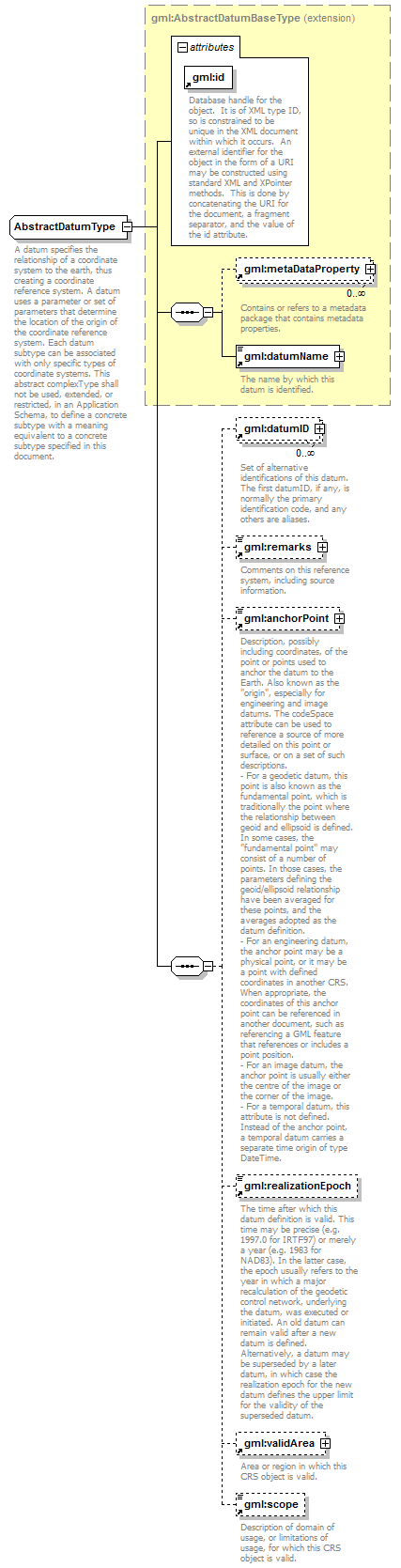 |
||||||||||||||
| namespace | http://www.opengis.net/gml | ||||||||||||||
| type | extension of gml:AbstractDatumBaseType | ||||||||||||||
| properties |
|
||||||||||||||
| children | gml:metaDataProperty gml:datumName gml:datumID gml:remarks gml:anchorPoint gml:realizationEpoch gml:validArea gml:scope | ||||||||||||||
| used by |
|
||||||||||||||
| attributes |
|
||||||||||||||
| annotation |
|
||||||||||||||
| source | <xs:complexType name="AbstractDatumType" abstract="true"> <xs:annotation> <xs:documentation>A datum specifies the relationship of a coordinate system to the earth, thus creating a coordinate reference system. A datum uses a parameter or set of parameters that determine the location of the origin of the coordinate reference system. Each datum subtype can be associated with only specific types of coordinate systems. This abstract complexType shall not be used, extended, or restricted, in an Application Schema, to define a concrete subtype with a meaning equivalent to a concrete subtype specified in this document. </xs:documentation> </xs:annotation> <xs:complexContent> <xs:extension base="gml:AbstractDatumBaseType"> <xs:sequence> <xs:element ref="gml:datumID" minOccurs="0" maxOccurs="unbounded"> <xs:annotation> <xs:documentation>Set of alternative identifications of this datum. The first datumID, if any, is normally the primary identification code, and any others are aliases. </xs:documentation> </xs:annotation> </xs:element> <xs:element ref="gml:remarks" minOccurs="0"> <xs:annotation> <xs:documentation>Comments on this reference system, including source information. </xs:documentation> </xs:annotation> </xs:element> <xs:element ref="gml:anchorPoint" minOccurs="0"/> <xs:element ref="gml:realizationEpoch" minOccurs="0"/> <xs:element ref="gml:validArea" minOccurs="0"/> <xs:element ref="gml:scope" minOccurs="0"/> </xs:sequence> </xs:extension> </xs:complexContent> </xs:complexType> |
XML Schema documentation generated by XMLSpy Schema Editor http://www.altova.com/xmlspy